While smartphones can handle navigation, they simply can’t compete with the advanced features of a dedicated GPS device. For nearly a decade, we’ve tested the top hiking GPS devices, narrowing it down to 7 standout options guaranteed to guide you precisely where you need to go.
These recommendations are no flukes. We’ve put them through the wringer, mapping waypoints, navigating tough terrain, and analyzing trip data. Dive into our list of top picks through this article!
What is a hiking GPS devices?
At its most basic, a GPS device provides your precise location. This core function is the foundation for additional features like navigation with maps and routes, trip tracking for post-adventure sharing, and even acting as a search-and-rescue beacon in emergencies.
The way a GPS device pinpoints your location is by receiving signals from a network of Global Positioning System (GPS) satellites. Essentially, the device acts as a receiver, requiring signals from at least three satellites to triangulate your position accurately. The more satellites it connects with, the greater the accuracy and speed of the location fix.
This process is similar to traditional map and compass navigation. By identifying three landmarks and using a compass to determine their directions, you can draw lines on a map to find where they intersect – your location. A GPS device automates and enhances this process, displaying your position in coordinates like latitude and longitude.
However, even the best GPS device isn’t foolproof. If the batteries die or the device malfunctions due to water exposure or a storm, basic map and compass skills remain an essential backup for any hiker.
1. Garmin GPSMAP 67 ($499.99 on Amazon)
- Screen Size: 3 Inches
- Connectivity Technology: Bluetooth, USB
- Map Type: North America
- Included Components: GPSMAP 67 or GPSMAP 67i handheld device, type-A to type-C USB cable, carabiner clip, documentation
- Battery Life: 180 Hours
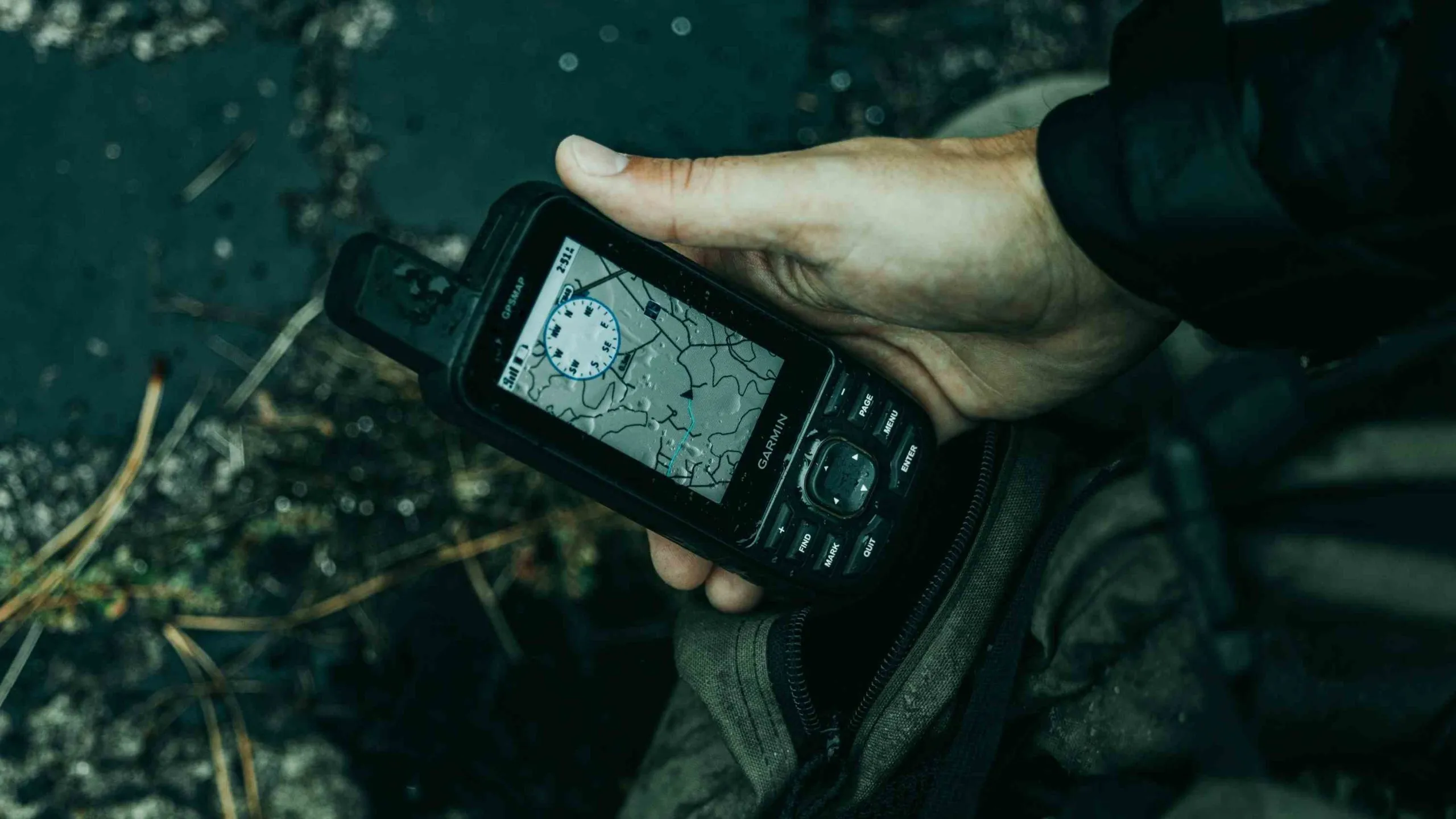
The Garmin GPSMAP 67 is a top-tier hiking GPS device renowned for its exceptional accuracy and reliability, making it a standout choice for serious adventurers. Thanks to its multi-band technology, its advanced quad-helix antenna ensures a robust connection to multiple satellite networks, even in challenging environments like dense forests or narrow canyons. This hiking GPS device also features an impressive lithium battery that can last 160+ hours in standard mode and up to 800 hours in battery-saving expedition mode.
Garmin has packed this unit with 16GB of internal memory, significantly more than most competitors, and it comes preloaded with detailed topographic maps for the US and Canada. Additionally, users can access high-resolution satellite imagery via Garmin’s Bird’s Eye Imagery without a subscription. For those in the cell service range, the GPSMAP 67 can sync with a smartphone to overlay real-time weather data on maps, adding another layer of functionality.
While these features come at a premium price, this hiking GPS device is worth the investment for expedition trips or professional fieldwork. However, it might be more than necessary for casual outdoor use. Its button-based interface lacks a touchscreen, but the layout is user-friendly, and the buttons perform reliably in extreme cold.
>> Related articles that you may be interested in: Top 7 Winter Survival Kits: A Comprehensive Review on Amazon
2. Garmin inReach Mini 2 ($409.99 on Amazon)
- Screen Size: 0.9 Inches
- Connectivity Technology: USB
- Map Type: Satellite
- Included Components: 1x E-Bank, 1x Car Charge; 1x Wall Charger, 1x USB cable, 1x Carabiner, 1x Garmin inReach Mini 2 Satellite Communicator
- Battery Life: Up to 14 days
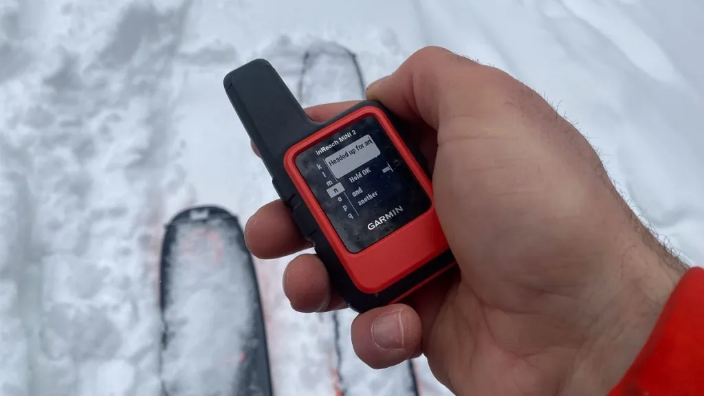
The Garmin inReach Mini 2 stands out among hiking GPS devices for its lightweight, compact design, making it a favorite for weight-conscious adventurers. While its primary features include satellite messaging and an SOS function, it also offers tracking, weather updates, maps, and navigation. The latest version improves on its predecessor with multi-GNSS support for better accuracy, a digital compass, increased storage for maps and routes, and significantly extended battery life. These upgrades, combined with its small size and competitive pricing, make the inReach Mini 2 a go-to choice for hikers, climbers, and backcountry explorers.
However, the Mini 2 has its limitations. This hiking GPS device relies heavily on pairing with a smartphone, which can be less durable and has limited battery life in rugged conditions. While it’s possible to use the device independently, its small black-and-white screen and button-based interface are less intuitive compared to other GPS devices. Additionally, accessing its satellite communication features requires a subscription plan, ranging from $12 to $65 per month. That said, most GPS functionality remains accessible without a subscription. For those who prioritize safety and lightweight gear, the Garmin inReach Mini 2 is an excellent companion.
3. Garmin eTrex 32x ($276.99 on Amazon)
- Screen Size: 2.2 Inches
- Connectivity Technology: ANT+
- Map Type: Topographical
- Included Components: eTrex 32x; USB Cable; Documentation
- Battery Life: 25 Hours
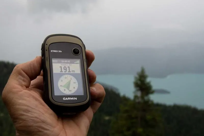
If you’re looking for a no-frills hiking GPS device that excels in navigation while keeping things simple, the Garmin eTrex 32x is an excellent choice. Despite its compact design, this unit delivers impressive navigation accuracy and functionality, holding its own against more advanced models. Preloaded with Garmin’s TopoActive base map, this hiking GPS device provides a wealth of information, including urban and wilderness trails, contour lines, and points of interest. This eliminates the hassle of manually uploading maps, with preloaded data tailored to your region of purchase.
The eTrex 32x’s pinpoint accuracy is achieved through its ability to connect with multiple satellite networks, including GPS and GLONASS, and is further enhanced by a barometric altimeter and a 3-axis digital compass. Despite these advanced features, the device remains lightweight and compact, making it easy to slip into your pocket or pack for a day hike.
However, the eTrex 32x isn’t without its limitations. Its small screen makes it less suitable for on-the-road navigation. While it supports Garmin’s BirdsEye Satellite Imagery, its connectivity options are limited to ANT+, lacking Bluetooth and Wi-Fi capabilities. This means it doesn’t integrate with apps like Garmin Connect or Garmin Messenger, which some users might miss. The joystick and T9-style keyboard may also feel outdated compared to modern touchscreens, making data entry a bit more tedious.
>> Related articles that you may be interested in: The 9 Best Balaclavas For Cold Weather: Must Have in Winter
4. Garmin Montana 700 ($552.54 on Amazon)
- Screen Size: 5 Inches
- Connectivity Technology: Wi-Fi
- Map Type: North America
- Included Components: Montana 700; Lithium-ion battery pack; USB cable; Documentation
- Battery Life: 18 hours (330 in expedition mode)
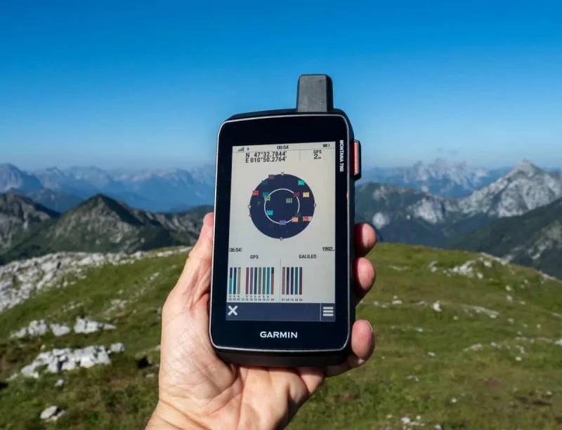
Handheld GPS devices have historically struggled with user experience, but the Garmin Montana 700 sets a new standard. Its standout feature is a vibrant 5-inch touchscreen, which replaces clunky button-based navigation with smartphone-level convenience. Scrolling through menus or navigating maps feels intuitive, and the Gorilla Glass display ensures easy readability even under direct sunlight. Despite the modernized interface, this hiking GPS device doesn’t skimp on performance. It includes ABC sensors (altimeter, barometer, compass), multi-GNSS support (GPS, GLONASS, and Galileo), and a comprehensive suite of topographic maps. For added connectivity, the upgraded Montana 700i ($700) includes inReach technology, allowing for satellite messaging and SOS functionality in areas without cell service.
For those venturing into rugged terrain or undertaking extended expeditions, the Garmin Montana 700 combines durability, accuracy, and a user-friendly design that’s hard to match, making this hiking GPS device a top contender for modern explorers.
5. Garmin Foretrex 801 ($237.90 on Amazon)
- Screen Size: 2.2 Inches
- Connectivity Technology: Bluetooth
- Map Type: North America
- Included Components: Foretrex 801 device, hook and loop wrist strap, USB-C cable, documentation
- Battery Life: 100 Hours
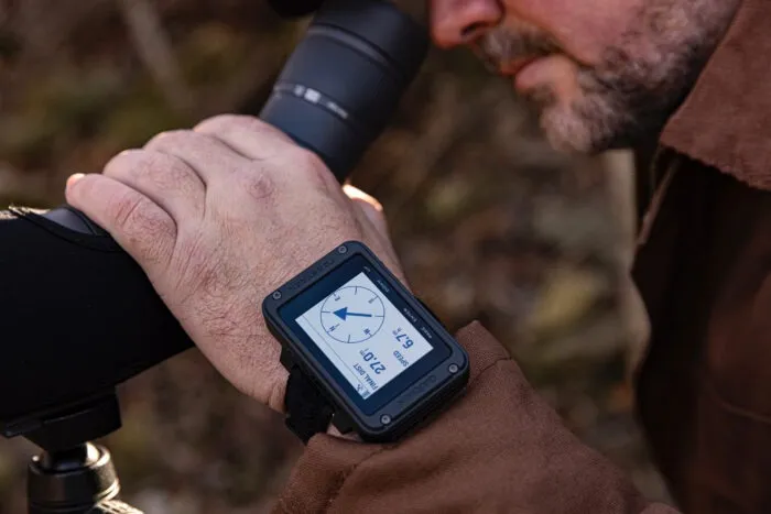
The Garmin Foretrex 801 offers a fresh take on traditional GPS devices with its wrist-mounted design, providing hands-free convenience. Similar to Garmin’s top-tier models, the Foretrex 801 boasts fast satellite acquisition and precise tracking, supported by GPS, GLONASS, and Galileo, along with multi-frequency positioning, a 3-axis compass, and a barometric altimeter. Its battery life of up to 100 hours in navigation mode is respectable, and the rugged, military-grade construction ensures it can withstand tough conditions. In essence, this hiking GPS device delivers the core functionality of a handheld GPS without the added bulk, making it a practical and efficient choice for the right user.
That said, the Foretrex 801 does have some limitations. Unlike more advanced models, this hiking GPS device doesn’t support detailed topographic maps, relying instead on a breadcrumb trail and the 3-axis compass for navigation. Additionally, its 2.2-inch screen, while small compared to handheld units, remains easy to read even in bright sunlight. Ultimately, the Foretrex 801 isn’t designed for everyone, but its streamlined interface, robust durability, and impressive battery life make it an excellent choice for backcountry adventurers who value simplicity and functionality.
>> Related articles that you may be interested in: The 9 Best Gloves For Winter Camping: Full Review
6. Bushnell BackTrack Mini GPS ($68.31 on Amazon)
- Screen Size: 2.25 Inches
- Connectivity Technology: Bluetooth
- Map Type: Worldwide
- Included Components: BackTrack Mini GPS, Adapter Plate, Carabiner
- Battery Life: 24 Hours
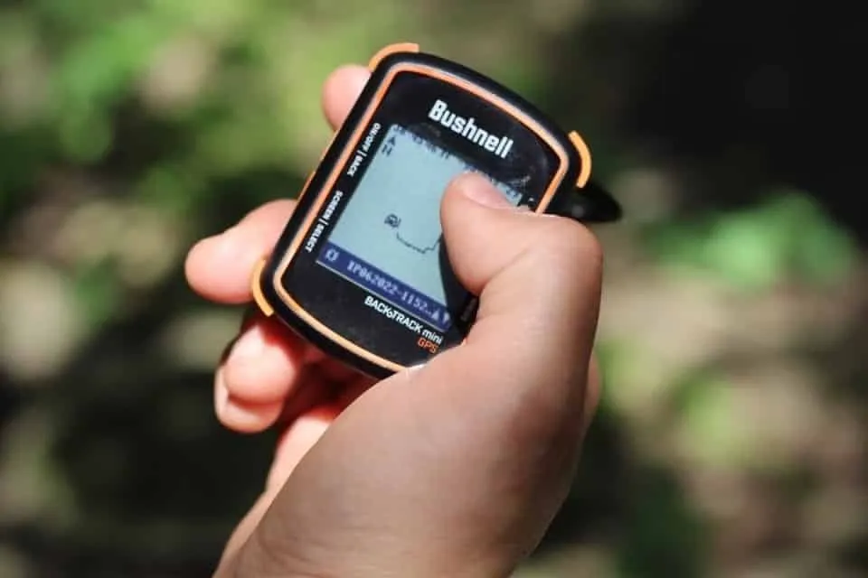
The Bushnell BackTrack Mini GPS is an excellent choice for those new to GPS devices or anyone who prefers simplicity over the complex features found in pricier models. It’s a reliable, no-frills option that offers the essentials – breadcrumb tracking – without all the extra functions that often add to the cost.
This hiking GPS device is operated with just four buttons and specializes in guiding you back to your starting point, displaying your path as a series of breadcrumbs. You can also drop waypoints along the way but don’t expect detailed maps or trails. It’s all about retracing your steps.
During our testing, we ventured to a high alpine lake through snow-driven winds that quickly concealed our tracks. The backtracking feature was invaluable in this situation, providing clear direction when visibility was limited. Keep in mind, though, that it offers a basic 2D view, so you’ll need a bit of imagination when it comes to navigation. Plus, with the Bushnell Connect app, you can upload your trips, make edits, and share them with others, adding a social aspect to your adventures.
7. Garmin eTrex 22x ($159.99 on Amazon)
- Screen Size: 2.2 Inches
- Connectivity Technology: Bluetooth
- Map Type: Topographical
- Included Components: eTrex 22x; USB Cable; Documentation
- Battery Life: 25 Hours
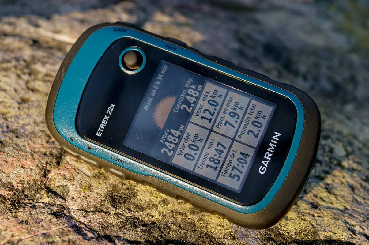
The Garmin eTrex 22x is a versatile handheld hiking GPS device designed for outdoor enthusiasts, offering a robust set of features to enhance navigation and exploration. It features a 2.2-inch sunlight-readable color display, providing clear visibility in various lighting conditions. The device is built with durability in mind, boasting an IPX7 water rating that protects it against rain and splashes, making it suitable for rugged outdoor use.
Preloaded with TopoActive maps, this hiking GPS device includes detailed information on streets, trails, waterways, and points of interest, allowing users to navigate off the beaten path confidently. It supports both GPS and GLONASS satellite systems, ensuring reliable tracking even in challenging environments. With 8GB of internal memory and a microSD card slot, users can easily download additional maps to suit their specific needs.
The eTrex 22x allows for the storage of up to 2,000 waypoints and 200 routes, making it easy to save favorite locations and plan future adventures. It also features paperless geocaching capabilities, enabling users to download geocache information directly to the device. With a battery life of up to 25 hours using two AA batteries, the Garmin eTrex 22x is an excellent companion for hiking, biking, or any outdoor activity where reliable navigation is essential.
Why use the GPS for Hiking?
Using GPS for hiking provides numerous advantages that enhance safety, navigation, and overall enjoyment of outdoor adventures. One of the primary benefits is accurate navigation, as hiking GPS devices allow hikers to pinpoint their exact location anywhere on the trail, eliminating uncertainties associated with traditional maps and compasses. This capability is particularly valuable in remote areas where trails may be less defined or poorly marked.
Additionally, GPS units offer real-time tracking and route recording features, enabling hikers to monitor their progress, distance traveled, and elevation changes throughout their journey. This data can be crucial for planning and adjusting routes based on physical exertion or time constraints. Many hiking GPS devices also include SOS functions, allowing users to send emergency signals if they encounter difficulties, which can be a lifesaver in critical situations.
Furthermore, GPS devices often come with preloaded topographic maps that display trails, landmarks, and terrain features, making it easier to navigate unfamiliar landscapes. They are typically more durable and weather-resistant than smartphones, designed to withstand harsh outdoor conditions without compromising performance. Overall, incorporating GPS technology into hiking gear significantly enhances safety, navigation accuracy, and the overall hiking experience.
How to choose & use a Hiking GPS devices
Choosing and using a hiking GPS device involves several important considerations to ensure you select the right model for your needs and can effectively navigate while on the trail.
How to Choose a Hiking GPS Device
Assess Your Needs: Consider your hiking style, frequency, and the types of terrain you’ll encounter. Casual hikers might find smartphone apps sufficient, while avid or backcountry hikers should opt for dedicated handheld GPS devices with advanced features for reliability in remote areas.
Types of GPS Devices:
- Handheld GPS Devices: Ideal for serious hikers, these devices operate independently of cellular networks and often come with detailed topographic maps, rugged builds, and longer battery life. Look for models like the Garmin GPSMAP 67 for comprehensive navigation capabilities.
- Smartphone Apps: While convenient, smartphones may not be as reliable due to battery life and signal dependency. However, they can be useful for shorter hikes in well-covered areas.
- Wearable GPS Devices: Options like the Garmin Instinct 2 offer portability and essential features for outdoor enthusiasts, including heart rate monitoring and multi-satellite support.
Key Features to Consider:
- Mapping and Navigation: Ensure the device has detailed maps and the ability to preload routes. Features like waypoint marking and altitude tracking are beneficial for more complex hikes.
- Connectivity: Devices with Bluetooth or Wi-Fi can sync with other devices, allowing for easy updates and data sharing. Some models even offer live tracking capabilities.
- Durability: Look for weatherproofing and rugged construction to withstand outdoor conditions.
- Budget Considerations: Prices vary widely based on features. Determine which functionalities are essential for your hikes to balance cost with your requirements.
How to Use a Hiking GPS Device
- Familiarize Yourself with the Device: Before hitting the trail, learn how to operate your GPS unit, including how to set waypoints, load routes, and interpret navigation data.
- Plan Your Route: Use mapping software or apps to plan your route in advance. You can often import GPX files into your GPS device for easy navigation during your hike.
- Calibrate Before Starting: Ensure your GPS device has a clear satellite signal before you begin hiking. Calibrate the compass if necessary to improve navigation accuracy.
- Regularly Update Maps and Software: Keeping your device’s firmware and maps up-to-date ensures optimal performance and accuracy during your hikes.
- Backup Navigation Tools: Always carry a traditional map and compass as a backup in case of technical issues with the GPS device. This is crucial for safety in remote areas where battery life or signal may be compromised.
FAQs
Is a GPS worth it for hiking?
Hiking GPS devices are incredibly handy for situations like venturing off established trails, navigating areas where the path is obscured (such as under snow), or when you need reliable guidance in harsh conditions like extreme cold or heavy rain, where a smartphone might not perform effectively.
Can I use my phone as a hiking GPS?
Your smartphone can serve as a highly effective GPS device for wilderness adventures. Even far from cell service, it continuously receives satellite signals. By pairing it with the appropriate app, you can transform your phone into a cost-effective and dependable navigation solution.
What is the difference between a GPS logger and a GPS tracker?
A GPS logger records location data locally on the device, allowing users to access and download it later, while a GPS tracker transmits real-time location data to a server or platform, enabling immediate tracking and monitoring.