
Navigating hiking trails may seem intuitive at first, but to safely explore any outdoor environment, understanding how to read hiking trail signs is essential. These signs are more than just helpful hints, they’re part of a carefully designed system that ensures safety, preserves ecosystems, and keeps hikers from getting lost. Learning how to read hiking trail signs will not only boost your confidence in the wilderness but also help you make informed decisions as you traverse different terrains. Whether you're a beginner or a seasoned trekker, becoming fluent in trail sign language is a must for anyone serious about hiking.
This guide from the National Park Shops breaks down everything you need to know about how to read hiking trail signs. From trail markers and blazes to symbol meanings and pro-level navigation tips, you’ll be equipped with the knowledge needed to handle any trail system with clarity and care.
What are Trail Markers Used For: Important Symbols
Trail markers are essential communication tools used to guide hikers along a specific route. They appear in various forms, paint blazes, metal signs, etchings, or natural materials, and help ensure you're on the correct path. Knowing how to read hiking trail signs includes understanding these symbols, which can indicate direction, trail difficulty, or intersecting paths. They’re especially critical in remote or complex trail systems where GPS signal may not be reliable.
Key symbols on hiking trail signs include arrows (indicating direction), color-coded shapes (signifying trail difficulty), and junction numbers or letters. For instance, a blue blaze might indicate an easier loop trail, while a red or black marker may denote a more strenuous route. Learning how to read hiking trail signs allows you to interpret these symbols quickly and avoid costly navigation errors. It's also a way to respect trail etiquette and environmental preservation efforts.
Where to Find Trail Markers?
Understanding how to read hiking trail signs starts with knowing where to look for them. Trail markers are typically placed at eye level on trees, rocks, or posts, and are most commonly found at trailheads, junctions, and difficult-to-navigate areas. They may also be located on bridges, fences, or trail barriers in open terrain where trees aren't available. The frequency and placement of markers depend on the park or region’s trail management strategy.
In areas with thick forests, trail blazes are often found every few hundred feet to help hikers stay on track. Open desert or alpine environments may rely more on cairns or posts since fewer fixed objects are available for marking. When learning how to read hiking trail signs, train your eye to spot subtle indicators like worn paint, stacked rocks, or faded plaques. Consistently checking for these signs prevents you from straying off-course and boosts your situational awareness.
>> Read More: How To Start Hiking: A Detailed Guide for Beginners
Trail Blazing Methods: Pros and Cons
Trail blazing is the practice of marking trails to guide hikers and ensure safe navigation through natural landscapes. Each method comes with its own strengths and limitations, and recognizing them is a critical part of learning how to read hiking trail signs.
Pros:
-
Painted blazes are color-coded and highly visible, especially in wooded areas. They are low-cost and can convey both direction and trail difficulty with minimal resources.
-
Cairns are effective in open terrain like deserts or rocky plateaus where there are no trees or fixed structures. They are easy to construct and require no tools or materials.
-
Posts and affixed markers provide detailed, often durable information such as trail names, arrows, and distances. These are particularly valuable in high-traffic or open environments where frequent navigation updates are essential.
-
Flags or ribbons serve as temporary but useful tools during group hikes or in emergency situations where quick guidance is needed.
Cons:
-
Painted blazes can fade with time or weather exposure, making them hard to see. They also require periodic upkeep.
-
Cairns may be mistaken for random rock piles, can be knocked over easily, and are sometimes misused by hikers unfamiliar with proper construction.
-
Posts and affixed markers are more costly to install and maintain, and they may be spaced far apart, making navigation between them less intuitive.
-
Flags or ribbons are non-permanent, prone to disintegration or loss in wind and weather, and can create litter if not removed after use.
By understanding the pros and cons of each method, you’ll be better prepared to navigate a trail confidently and responsibly. Mastering how to read hiking trail signs starts with identifying the system in place and interpreting it based on terrain, visibility, and environmental conditions.
>> Read More: 7+ Hiking Safety Tips for Beginners: How to Best Prepare
6 Common Types of Trail Blazes
To further understand how to read hiking trail signs, it's important to explore the most common blaze types you'll encounter. These serve as visual cues that vary by environment, terrain, and park system.
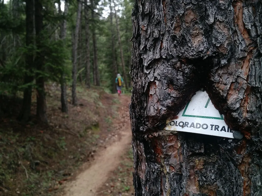
Paint
Paint blazes are one of the most widespread and recognizable ways to mark a trail. These are usually rectangles of color painted directly on trees, rocks, or man-made structures. Learning how to read hiking trail signs often starts with paint blazes because they offer quick, visual information. Colors can denote trail difficulty or identity, for example, white blazes for the Appalachian Trail or blue for side trails. The shape and sequence of the paint can also indicate direction: a single rectangle usually means “straight ahead,” while two offset blazes suggest a turn.

Cairns (or ‘ducks’)
Cairns are stacked rocks placed strategically to guide hikers across areas where paint or signs are impractical, such as open rocky terrain or deserts. They're especially common in national parks in the Southwest. To understand how to read hiking trail signs in these regions, you need to recognize cairns as intentional markers rather than natural rock piles. However, they can be accidentally knocked over or tampered with, so it's vital to observe their direction carefully and not build your own.
>> Read More: 10 Best Family-friendly Hiking Trails To Take with Kids

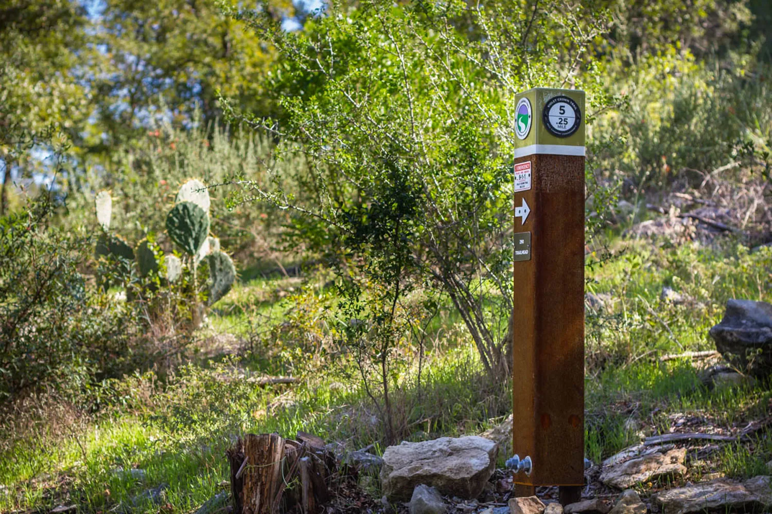
Posts
Posts are vertical markers made of wood, metal, or composite materials. They're used when trees or natural structures aren’t available, especially in alpine, prairie, or desert settings. Posts often include affixed plaques, trail names, arrows, or even QR codes. To truly grasp how to read hiking trail signs, it’s helpful to stop and examine these posts closely, they often provide layered information, including distances and elevation data. They're durable and effective but may be placed far apart, requiring alertness between posts.
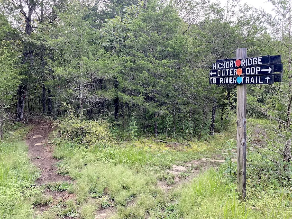
Affixed Markers
Affixed markers are signs bolted or nailed to trees, rocks, or posts and often provide clear, durable trail instructions. These may feature icons, maps, and even multilingual text. If you’re learning how to read hiking trail signs in managed parks or well-trafficked trails, you’ll encounter affixed markers frequently. They're usually placed at trailheads, junctions, or scenic viewpoints to help hikers verify their location. Their permanence and clarity make them essential in high-traffic areas.
>> Read More: 11 Benefits of Hiking for Health and More

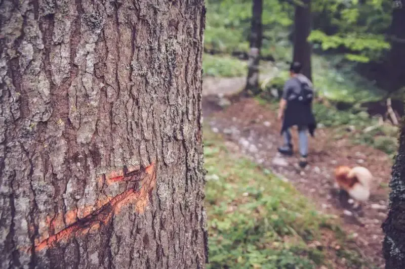
Etchings
Etched trail signs are carved directly into wood, metal, or rock surfaces and are valued for their durability. These types of markers are most common in national parks, wilderness preserves, or older trail systems. If you want to fully understand how to read hiking trail signs, it’s crucial to pay attention to these sometimes-subtle engravings. While they don’t offer color coding, they provide reliable information in any weather condition. They're often found at trailheads or major trail intersections.
Flags
Flags or ribbons tied to branches are a more temporary form of trail marking, often used during group hikes, races, or emergency scenarios. These lightweight markers are easy to spot but can blow away or degrade over time. When considering how to read hiking trail signs, remember that flags should not be your only source of navigation. They’re best used as supplemental guides and should be removed after use to avoid littering and confusion for other hikers.
>> Read More: How To Read a Hiking Trail Map Quickly and Easily
How to Read Hiking Trail Signs
Reading trail signs accurately requires more than just glancing at symbols, it involves interpreting multiple layers of information, including context, direction, terrain, and frequency. Every trail sign is part of a system designed to provide guidance and prevent disorientation. A strong grasp of how to read hiking trail signs includes decoding color codes, directional cues, elevation indicators, and intersection notations. For example, green signs are typically used to mark easy or beginner-friendly trails, while black or red are often reserved for more challenging or hazardous paths.
Directional arrows are another critical feature, helping hikers remain oriented throughout their journey. These are commonly accompanied by junction numbers or trail names that clarify where the trail splits, merges, or ends. One often overlooked skill in learning how to read hiking trail signs is understanding consistency in blaze placement and pattern. Trail systems usually follow a standardized approach; for instance, a double blaze with the upper mark shifted right indicates a right turn ahead, while a shift to the left means a left turn. Combining this understanding with topographic awareness and map literacy equips hikers to handle unexpected detours, ensure safety, and navigate unfamiliar trails with confidence.
>> Read More: Hiking Alone Safety Tips: How To Protect While Solo Hiking
Pro Tips: Trail Navigation Tips for Reading Trail Markers
Mastering how to read hiking trail signs can dramatically improve your hiking safety and efficiency. Here are some expert strategies to enhance your trail navigation:
-
Pre-study your map: Familiarize yourself with trail blazes and key intersections before setting out.
-
Use a compass or GPS as a backup: Trail markers aren’t foolproof, technology can supplement your navigation.
-
Pay attention to changes in terrain: A sudden lack of markers often signals a wrong turn.
-
Check your direction regularly: Even if the path seems obvious, verify with each new marker.
-
Observe marker condition: Faded or altered signs can lead you astray, trust your instincts if something feels off.
With consistent practice, your ability to read hiking trail signs will become second nature. Over time, you'll instinctively know when to pause and reassess, even without clear signs. The combination of trail signs, natural awareness, and navigation tools is what transforms casual walkers into confident backcountry explorers.
Frequently Asked Questions
What is the average distance between two trail signs?
The average distance between trail signs varies by environment and governing agency. In wooded areas, you might see markers every 100–200 feet, while in deserts or alpine zones, spacing may increase to every 500 feet or more. When learning how to read hiking trail signs, remember that spacing will depend on visibility, trail complexity, and trail maintenance schedules.
Do they use the same blazing system?
Not all regions use the same blazing system, though many follow similar conventions. The Appalachian Trail, for example, uses white blazes, while side trails use blue. Western parks may favor cairns or etched signs instead. If you’re serious about mastering how to read hiking trail signs, research the specific park or trail system before your hike.
What are the indicators of hiking trails?
Common indicators of hiking trails include blazes (painted or etched), signage at junctions, directional arrows, and occasional distance markers. Terrain wear and footpath patterns can also guide the way. Knowing how to read hiking trail signs involves using all available clues in combination, not just looking for signs alone. Keep your senses engaged and trust a multi-sensory approach to stay on track.
>> Read More: